
Northern Cumbrian Coastal Defences
The Wall ends at Bowness on Solway, but Northern Cumbrian Coastal Defences continued for a further 25 miles with turf and wooden milefortlets (similar to the Wall’s first Milecastles in the West )’ There were turrets until Burrow Wall Fort a few miles south of Maryport with forts at Beckfoot and of course Maryport.(see Guide)
The fortlets were numbered in the 19th century assuming that there was a milefortlet {MF} every Roman mile. When the changes in coastline over 1900 years were better understood, it was obvious that a number did not exist. No decision was made to renumber the fortlets and so the original numbers were retained.
Roman Cumbrian Coastal Defences south of Bowness on Solway were contemporary with defensive structures on Hadrian’s Wall and were built about the same time.

Northern Cumbrian Coastal Defences
It is possible that there may have been a ditch or even a palisade connecting the forts, milefortlets and turrets. There are some indications of a ditch and a wooden palisade. This would be similar to the Limes on the German frontier.
Mile Fortlet 1 Biglands House

MF1-RAISED-BANK-IN-FRONT-FARMHOUSE-SOUTH-OF-BOWNESS
About a mile south of Bowness is Mile Fortlet 1 (NY 2086561914). Like Hadrian’s Wall, the coast defences originally did not envisage forts so they had a short life. They were built of turf and wood and never were rebuilt in stone. It is located at Biglands House and from the road you can just about see the platform of the fortlet from the road in front of the house. It was 75ft by 55ft, a typical size of a Wall Milecastle with an area of about 300 square yards.
There appeared to be 2 gates and 2 buildings in the fortlet and abandoned about 140AD. The milefortlet was rebuilt on the return to the Wall after the abandonment of the Antonine Wall. It was modified about 30 years later, and then abandoned by the end of the 2nd century.
Milefortlet 5 Cardurnock and Milefortlet 9

Turf Milecastle replica
The next fortlet of interest is 4 miles south west along the coast on a slightly elevated ridge measuring 126ft by 100/87 ft., with a ditch surrounding the turf and wooden walls. Nothing is visible. The fortlet is likely to have been built in the Hadrianic period.

LOCATION-OF-Milefortlet 5
It was the largest of the Milecastle and milefortlets in the Wall complex even after it was reduced in size by 40% perhaps 30 years later, when the turf wall would need renewing, and finally abandoned about 200AD. Milefortlet 5 sits on the north side of Moricambe Bay into which the Wampool and Waver Rivers flow.

VIEW-NORTH-FROM-MF5 TO MF 9
Milefortlet 9 was on the south bank of the Bay, which was about the same size as the reduced Milefortlet 5, indicating that these fortlets may have had a special purpose. The coastline has significantly changed here in the last 1900 years. Perhaps Milefortlets 6, 7 and 8 never existed and MF 5 and MF9 were made unusually large to compensate.
Kirkbride Roman Fort

KIRKBRIDGE-ROMAN-FORT-BEST-GUESS-AT-LOCATION
The diagram has been drawn following excavations, little can be seen on the ground. In the middle of the Western Wall, a 12th century church was built, using material from the fort.

CHURCH-BUILT-ON-WEST-WALL-OF-KIRKBRIDE-ROMAN-FORT
At the head of the estuary of the River Wampool, in a commanding position south of the river was the fort. The estuary flowed into the Moricambe, which is a large bay cutting deeply into the coastline and would be useful for raiders from the sea.
That and control of the river crossing explains the fort’s location, but the coastline 1900 years ago is unclear. It is possible that the fort controlled a harbour

Replicate of turf and wood fort at Lund, similar to the first fort at Kickbride
The fort was thought to be just over 5 acres with a turf wall 30 ft. wide. at the base, similar to the first forts on the Western Wall, built 40 years later.
It is likely that it was built after 90AD perhaps as late as 105AD.
Prior to the Wall, a road was built between Corbridge and Carlisle about 80AD 20 years later it became the de facto boundary of the Empire. It is likely the road was extended to Drumburgh and then to Kirkbride about 20 years before the Wall was built.
Nothing is known of the garrison, but from the size of the fort, it was either a large infantry cohort or a cavalry cohort or more likely a mixed cohort.
The problem we have is, whether it was part of Hadrian’s Western defences. Or was it abandoned in 120 AD? It may have been reduced in size and incorporated into the defences, its location indicates a fort was needed at this site.
There appears to be no known Roman name.
Beckfoot Roman Fort/Bibra

BECKFOOT-ROMAN-FORT-AERIAL
Beckfoot is mid-way between Bowness, the last fort on the Wall in the west, and Maryport to the South, which probably has been established perhaps two decades earlier. Located on the coast with good views of the south west to Maryport and to the North.

SITE-OF-BECKFOOT-ROMAN-FORT
Looking at the site there is no indication that there was anything here, but aerial photography and excavations give us a fairly detailed plan of the fort.
It is likely that the forts were not in the original plan, but added later, which is the case with all the Wall forts. The fort measured 283ft by 405ft, with an area of 3.25 acres. The plan above comes from excavations dating back to 1880. The fort includes the usual 4 gates, interval towers and 4 corner towers, with no visible remains. Usually on the West Wall, there was a platform for a ballista ( effectively a crossbow, firing bolts and shot weighing 25 kg to 75 kg bolts, probably good enough to sink a ship of that era).

Seaborne attack had to be a possibility. The fort was occupied from the 120s AD to the end of the 4th century. It was built in stone, but the first fort may have been turf and wood, like the Western Wall forts. There are indications of roads heading north and south.
Typically this type of fort would have housed 500 cohorts of infantry. Only one inscribed stone has been uncovered from Roman Beckfoot, which provides the name of one of its garrison units; Cohors II Pannoniorum. This was a five-hundred strong infantry unit from the province of Pannonia, the region of the modern Czech Republic
Going south there is not much to see; not much has survived, and not particularly well excavated, but there is an exception
Milefort 21
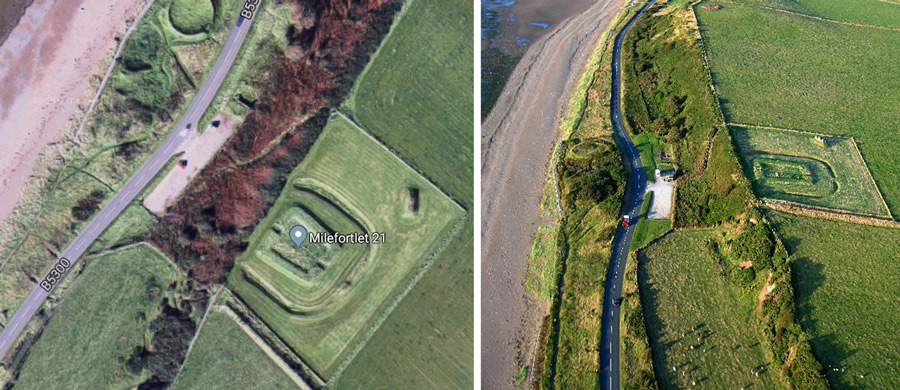
Located on the coast about 3 miles north of Maryport it is the best-preserved milefortlet (same as a Milecastle) on the Cumbrian coast. The north west outer turf and wood wall has been lost, as the cliff has eroded.
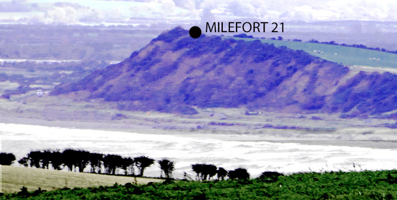
MF 21 FROM MARYPORT
It was built of turf and wood in the early 120s AD and occupied until about 140AD.

Swarthy-Hill-Fordlet-21 artist impression
It is surrounded on 3 sides by a large ditch and on the side facing the sea by a steep slope. Inside it contains 3 small barrack blocks of different wayouts and it is estimated to home 24 men. It is a short axis fortlet, measuring internally 47ft by 59ft with the longest side facing the sea, about 310 sq.yds. inside the Walls. There were gates on the north west and south east sides, each in a 10ft inclosure defined by 4 poles,
A road passes through the the fortlet but does not extend beyond the gates.
The fortlet has been fully excavated and conserved around 1990.
The site can be reached through a farm gate 250 yards south of the milefortlet. Do not use the car park immediately below the site, probably because the path up the cliff has collapsed.
This is the highlight of the